Science project
Create a Contour Map

Type
Grade Level
Difficulty of Project
Cost
Safety Issues
If making your own modeling dough, be careful cooking the dough on the stove.
Material Availability
Materials are readily available. The modeling dough may be purchased (ex. Play Doh) or made at home, if cream of tartar is available.
Approximate Time Required to Complete the Project
3 hours for basic project.
Objective
Mount You: Make a mini mountain out of dough, and then make a contour map out of your creation.
Materials and Equipment / Ingredients
- 2 cups play dough (* see recipe at end)
- 2 rulers (or 1 ruler and 1 pencil)
- Thin string, about 12 inches long. (Dental floss works well, if you have it)
- 1 Pencil
- 1 toothpick (or sharp pencil point)
- 2 sheets of paper.
- Scotch tape
Introduction
In this project, you will make your own mini-mountain, and then make a contour map of your mountain.
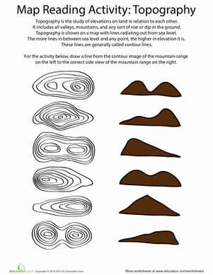
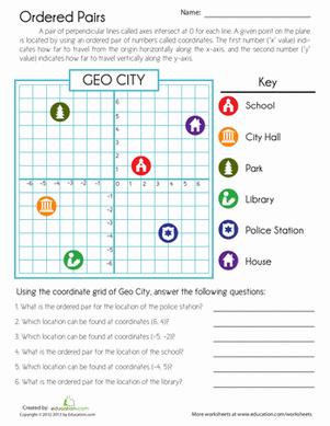
What’s a contour map? Let’s start with the word “contour.” A contour is a line that shows the border or outline of an object. A contour map is a 2-dimensional drawing of land. The map includes contour lines to show changes in the elevation of the land.
Here is a part of a contour map, showing the area of Half Dome in Yosemite National Park. The brown contour lines show every 40 feet of elevation change. The top of Half Dome is at 8836 feet. When the brown lines are close together, the elevation changes quickly.

The photograph will help you understand the contour map of Half Dome. The sheer face of rock is the part that is mapped with the contour lines very close together. The top of Half Dome that is fairly flat appears to have much more white space between the brown contour lines.

Each contour line shows all connected land that is at the same elevation. Contour lines may be drawn at every five-foot difference in height, every 100-foot difference in height, or at some other scale, depending on the terrain being mapped. The closer the lines are to each other, the more steep the terrain.
In this project, you will be making a map that is life-sized. That means you are using a scale of 1 to 1: one inch on the map represents one inch of distance on the model. Your contour lines will represent each one-inch change in elevation.
Research Questions
- If you make multiple contour maps, can you tell the difference between a mountain that is steep and a landscape that rises more gradually? How will the two maps differ?
- Let’s say you want to create a map of a real-world feature, like Half Dome in Yosemite. A rock formation like that may be 5000 feet wide. If you want your contour map to fit on a piece of 8.5 x 11 inch paper, what scale might you use?
Terms, Concepts and Questions to Start Background Research
In this science project, you make a contour map of a model mountain. The map shows the changes in elevation of your mountain. Contour maps are also called topographic maps. The U.S. Geological Survey makes topographic maps, including many at 1:24,000 scale
- Contour Map:A contour map is a 2-dimensional drawing of land, which includes contour lines to show changes in the elevation of the land. The use of contour lines allows a 2-dimensional map to show what land looks like in three dimensions: length, width and height.
- Elevation:Elevation is a measurement of how high you are above a fixed point, like sea level. It often is measured in feet or meters. At an elevation of 1,453 feet, you’d be standing on the one hundred and second floor of the Empire State Building, gazing down at the New York City skyline. At an elevation of 0 feet, you’d be standing in the lobby, waiting for the elevator. Get it? An elevator is a machine that enables you to easily change your elevation. To elevate means to lift up.
- Topographic map: Topographic maps display the three-dimensional characteristics of terrain on a two-dimensional surface. Topographic maps usually show and name both natural and manmade features, such as lakes, mountains, airports and roads. Topographic maps have many uses, including recreation, environmental management and emergency response planning.
- United States Geological Survey: The United States Geological Survey, abbreviated as the USGS, is the government agency responsible for producing topographic maps of the entire United States.
- Scale:The ratio of distances on a map to the corresponding values on Earth. The best-known USGS maps are 1:24,000-scale topographic maps. One inch on a map of that scale represents 2,000 feet. (See attached complete Half Dome map for an example.)
Experimental Procedure
Directions
- Knead your play dough, and make it into a mountain shape. You can have a single, pointy peak or a flat or round top – you decide. Try to make your mountain at least three inches high at the highest point.

- Fold a sheet of paper in half lengthwise, then fold it again widthwise. Unfold the paper, and trace the lines you made in the paper. Label the lines with the point of the compass: North, South, East and West.

- Place your dough mountain on the center of the piece of paper, where the lines cross. Where the outer edge of the dough meets the paper, the elevation is 0 inches. Use the pencil to trace the outline of your dough.

- Using the toothpick, carve a shallow, vertical (straight up and down) line on the clay, from the tip of the peak to the place where the bottom of your mountain meets the line marked South. This will be your first guideline. Carve a second line from the top of the peak down to the East line.

- Tie one end of the string around each ruler, at the 1-inch mark Tape the string in place so it doesn’t wiggle. (If you only have one ruler, you can use a pencil instead of the second ruler.)

- Keeping the short ends of the rulers flat on the ground, pull the string so that is slices through the clay. Put your fingers on the back edge of the dough as you slice front to back, to keep the dough from moving. You will be slicing your mountain into two sections: the bottom inch of your mountain, which is touching the paper, and the top part of your mountain, which is the part higher than one inch.

- Carefully separate the two sections of dough. Move the bottom section off of the first paper and onto the second paper.
- Using your guidelines, put the smaller, top piece of dough back on the paper. Make sure both guidelines on the clay match up to the guidelines on the paper.
- Now trace this section of dough with the pencil. Write 1” next to this line. All of the dough at this line started out one inch above the paper.

- Repeat steps 5 through 8 until you have reached the top of your mountain. Make sure to label your second cut 2”, your third cut 3” and so on.


- After you are done with each slice of dough, put it back on top of the first slice, on paper two, using your guideline to get it back in the same orientation. Note: You don’t have to adjust the string on the ruler: each slice on once inch above the previous one.
- Congratulations! You now have a contour map of your mountain.

Play Dough Recipe
Ingredients
- 1 Cup white flour
- ¼ cup salt
- 2 tablespoons cream of tartar
- 1 cup water
- 2 teaspoons food coloring
- 1 tablespoon vegetable oil
Directions
- Mix flour, salt and cream of tartar in pot.
- Mix in remaining ingredients.
- Cook over medium heat for 3-5 minutes, stirring often.
- Mixture is done when it forms a ball in center of pot.
- Remove from heat and let cool for at least 5 minutes before using.
Bibliography
- National Park Service Website: Yosemite
- USGS Map Locator
- Exploring Maps
- The Us Geological Survey National Map website
- USGS Topographic Maps
- USGS Topographic Mapping Booklet
Education.com provides the Science Fair Project Ideas for informational purposes only. Education.com does not make any guarantee or representation regarding the Science Fair Project Ideas and is not responsible or liable for any loss or damage, directly or indirectly, caused by your use of such information. By accessing the Science Fair Project Ideas, you waive and renounce any claims against Education.com that arise thereof. In addition, your access to Education.com's website and Science Fair Project Ideas is covered by Education.com's Privacy Policy and site Terms of Use, which include limitations on Education.com's liability.
Warning is hereby given that not all Project Ideas are appropriate for all individuals or in all circumstances. Implementation of any Science Project Idea should be undertaken only in appropriate settings and with appropriate parental or other supervision. Reading and following the safety precautions of all materials used in a project is the sole responsibility of each individual. For further information, consult your state's handbook of Science Safety.
Related learning resources